1
Request Details
2
Contact Info

What do you need?

Describe the product or service you are looking for

Your Contact Information

We will contact you as soon as possible

Request Submitted!

Thank you! We will contact you soon with the best offers.

Geoscan 201 Aerial Photography Complex

Geoscan 201 Aerial Photography Complex

Brand: Geoscan
$15,000 - $42,000 USD
MOQ: 1 sets

Key Features

Maximum flight duration: 180
Wingspan: 2.22 m
Maximum payload weight: 1.5 m² living area
Landing type: Parachute kcal

More from Geoscan

Multi-Functional Educational Drone - Pioneer Mini

Multi-Functional Educational Drone - Pioneer Mini

$90-$300
High-Precision Magnetic Survey Using Drones

High-Precision Magnetic Survey Using Drones

$9,000-$60,000
Aerial Photography Services with Geoscan UAV for Orthophoto Plans

Aerial Photography Services with Geoscan UAV for Orthophoto Plans

$300-$2,400
Aerial Photography Drone Complex "Geoscan 401

Aerial Photography Drone Complex "Geoscan 401

$15,000-$48,000
Geoscan 801 Unmanned Aerial System

Geoscan 801 Unmanned Aerial System

$9,000-$30,000
Aerial Photography Drone System Geoscan 701

Aerial Photography Drone System Geoscan 701

$36,000-$96,000
GeoScan Lite Aerial Photography Drone System

GeoScan Lite Aerial Photography Drone System

$9,000-$24,000
Geoscan Gemini Aerial Photography Complex

Geoscan Gemini Aerial Photography Complex

$9,000-$30,000
Multifunctional Educational Drone Assembly Kit - Geoscan Pioneer

Multifunctional Educational Drone Assembly Kit - Geoscan Pioneer

$150-$480
Geoscan Pioneer Max Drone Assembly Kit

Geoscan Pioneer Max Drone Assembly Kit

$420-$1,500

Description

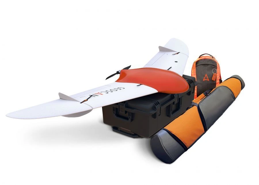
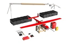
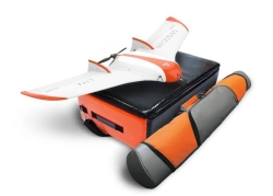
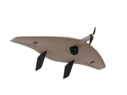
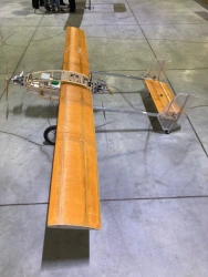
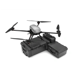
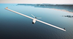
"Geoscan 201" is an aerial survey system that includes an unmanned aerial vehicle (UAV) of the "flying wing" type, a launcher and flight mission planning software.

Purpose
The unmanned complex is designed for automatic aerial survey with extended flight duration up to 3 hours. Due to this Geoscan 201 allows to survey a large territory in 1 flight and provide a larger range of coverage, additionally reducing logistics costs. The complex is equipped with automatic control system (autopilot), inertial navigation system, GPS/GLONASS signal receiver, payload management controller, digital communication channel for transmission of command and telemetry information and high-precision geodetic receiver.

Field of application
The materials obtained using the complex can be used for:
- creation of orthophotomaps in the range of scales 1:500 - 1:2000;
- three-dimensional modelling of a site locally.

Specifications

Maximum flight duration
180
Wingspan
2.22 m
Maximum payload weight
1.5 m² living area
Landing type
Parachute kcal
Type of takeoff
catapult kcal
Maximum route length
210 km
Battery type
lipo thousand m³
Engine type
Electric, collectorless cm³
Minimum safe flying altitude
100 m
Maximum allowable wind speed
B1/B8 2100/900 MHz kcal
Maximum takeoff weight
8.5 m² living area
Maximum flight altitude
4000 m

Related Products

GeoScan Lite Aerial Photography Drone System

GeoScan Lite Aerial Photography Drone System

$9,000-$24,000 USD
Maximum flight duration: 80
Maximum shooting area: 9
PLAZ LLC 🇷🇺
OMEGA Unmanned Aerial System - Multirotor Drone

OMEGA Unmanned Aerial System - Multirotor Drone

$1,500-$4,800 USD
Maximum flight duration: 45
Type of product according to PP RF 616: Helicopters and airplanes
AVAKS-GEOSERVICE LLC 🇷🇺
Drone Communication Jammer and Control Blocker "Zont

Drone Communication Jammer and Control Blocker "Zont

$9,000-$36,000 USD
Range: up to 1000
Operating frequency range: 0,4; 0,9; 1,2; 1,6; 2,4; 5,2; 5,8
ELIARS LLC 🇷🇺
Compact FPV Drone "Veles" for Aerial Surveillance

Compact FPV Drone "Veles" for Aerial Surveillance

$900-$3,600 USD
Overall dimensions: 330 x 410 x 70 mm
Weight: 1200
AERO-HIT LLC 🇷🇺
High-Voltage Line Inspection Drone Model "Spider

High-Voltage Line Inspection Drone Model "Spider

$9,000-$36,000 USD
Flight time: 15
Maximum takeoff weight: 30
FUTURE LABORATORY LLC 🇷🇺
Unmanned Aerial Vehicle Rubin A50

Unmanned Aerial Vehicle Rubin A50

$9,000-$30,000 USD
Flight time: B1/B8 2100/900 MHz
Type of product according to PP RF 616: Helicopters and airplanes
TS INTEGRATION LLC 🇷🇺
Unmanned Aerial Complex with Drones X4

Unmanned Aerial Complex with Drones X4

$9,000-$30,000 USD
Flight range: 5
Maximum allowable wind speed: 8
DRONE SYSTEMS LLC 🇷🇺
LUN-20 Unmanned Aerial System (UAS) ACI 791488 025

LUN-20 Unmanned Aerial System (UAS) ACI 791488 025

$90,000-$360,000 USD
Maximum flight duration of the BVS: At least 10 hours
Maximum radius of action of BVS (with the possibility of application of central heating centre) in automatic or semi-automatic m: At least 120 kilometres from NAPS
STC LLC 🇷🇺
Geoscan 401 Drone System with Vertical Takeoff and Landing

Geoscan 401 Drone System with Vertical Takeoff and Landing

$24,000-$72,000 USD
Max. flight duration: 60
Max. shooting area per 1 flight: 3.9
GEOSCAN LLC 🇷🇺
Remote Aerial Surveillance Drone System "Supercam S150

Remote Aerial Surveillance Drone System "Supercam S150

$9,000-$30,000 USD
Max. flight range: 110
Flight time: 2
DRONE SYSTEMS LLC 🇷🇺
Siberia-2 Unmanned Aerial System (UAS)

Siberia-2 Unmanned Aerial System (UAS)

$15,000-$48,000 USD
Flight range: 10
Payload weight, not more: 4
EVR LLC 🇷🇺
Unmanned Aerial Vehicle for Radio Signal Relay

Unmanned Aerial Vehicle for Radio Signal Relay

$9,000-$36,000 USD
Flight range: 360
Flight time: 180
TSARS OJSC 🇷🇺
FPV Drone Kit with Round Protective Guard "Kolobok

FPV Drone Kit with Round Protective Guard "Kolobok

$90-$300 USD
Maximum speed: 80
Flight duration: 10
RUSTEHDron LLC 🇷🇺
Remote Aerial Surveillance Drone System "Supercam S350F

Remote Aerial Surveillance Drone System "Supercam S350F

$9,000-$36,000 USD
Max. flight range: 240
Flight time: 4.5
DRONE SYSTEMS LLC 🇷🇺
Multi-Functional Educational Drone - Pioneer Mini

Multi-Functional Educational Drone - Pioneer Mini

$90-$300 USD
Maximum flight speed: 15
Camera: 2 mp; video resolution up to 1200x1600
PLAZ LLC 🇷🇺
M-10 89.2kW Two-Stroke Dual-Cylinder Air-Cooled Engine for UAVs

M-10 89.2kW Two-Stroke Dual-Cylinder Air-Cooled Engine for UAVs

$9,000-$30,000 USD
Weight: 47
Length: 557
NEW DIMENSION LLC 🇷🇺
Vertical Takeoff and Landing UAV System "IKS 7" (Fixar 007)

Vertical Takeoff and Landing UAV System "IKS 7" (Fixar 007)

$9,000-$30,000 USD
Maximum flight altitude: 5000
Maximum flight duration in "aeroplane" mode at vertical take-off and landing: 60
IKS LLC 🇷🇺
Gryphon-41 Unmanned Aerial System (UAS)

Gryphon-41 Unmanned Aerial System (UAS)

$15,000-$60,000 USD
Maximum flight duration: 1
Maximum flight range: 15
PLAZ LLC 🇷🇺
Kamikaze Drone RTD-K10 - Compact and Highly Maneuverable

Kamikaze Drone RTD-K10 - Compact and Highly Maneuverable

$900-$3,600 USD
Flight range: 10
Maximum flight altitude: 1000
RUSTEHDron LLC 🇷🇺
Automated Aviation System for Drones "Dandelion-3

Automated Aviation System for Drones "Dandelion-3

$9,000-$36,000 USD
Autonomy of flight in basic configuration: 40
Radius of flight: 10000
ATRI OJSC 🇷🇺
Request via WhatsApp